The short answer
From the roadside it is 1.1 km and about 25 minutes down a made path to the bridge, then 241 stone steps to the hermitage. Twenty to thirty minutes on the stairs is normal. The hard part is not the climb up the islet — it is the walk back up to the road afterwards, and almost nobody is warned about it.
Stage one: the gateway and the ridge
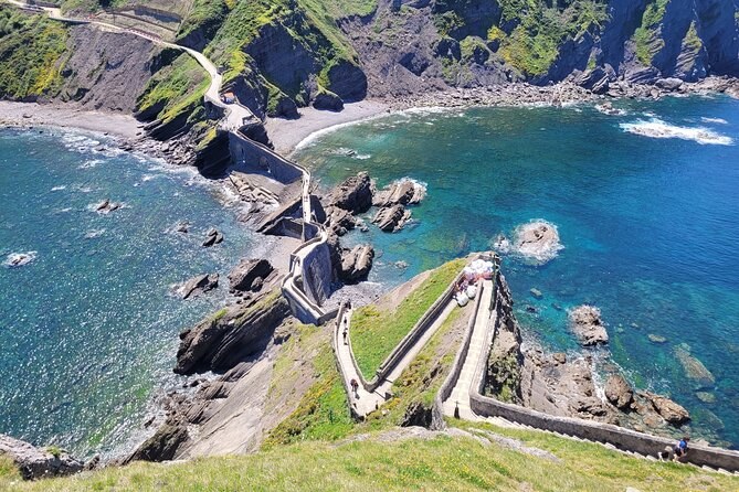
The walk starts at a timber gateway on the clifftop, signed with the name in letters big enough to photograph. From here the whole headland is laid out below: the causeway, the bridge, the staircase folding back on itself, and the hermitage on the summit. Give it a minute. This is the view that appears on every postcard, and it is easier to enjoy before the descent than after the climb back.
A waymarker just below the gateway signs Done Joane, the Basque name for the saint, at 1.1 km and 25 minutes. The same post points back to the Urizarreta car park at 250 metres. Both figures are honest for an unhurried pace.
Stage two: the path down
The path is made, wide enough for two, and drops steadily. There is loose gravel on the bends and the surface is smooth stone in places, which matters in the wet. Trainers with grip are enough; the sandals people arrive in are not.
- Surface: made path with gravel and worn stone sections.
- Gradient: continuous downhill, no flat stretches to speak of.
- Shade: patchy, from scrub and a few trees.
- Traffic: two-way, and busy from mid-morning onwards.
You lose sight of the islet for a while behind the shoulder of the hill, which makes the moment it reappears at the bottom worth the walk on its own.
Stage three: the bridge
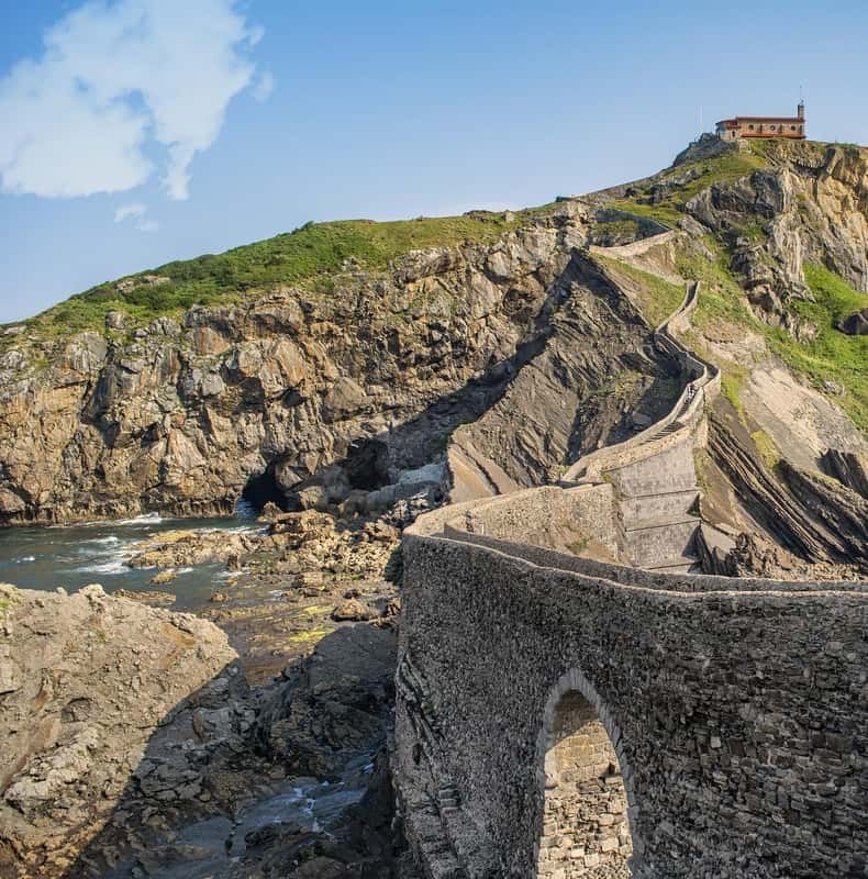
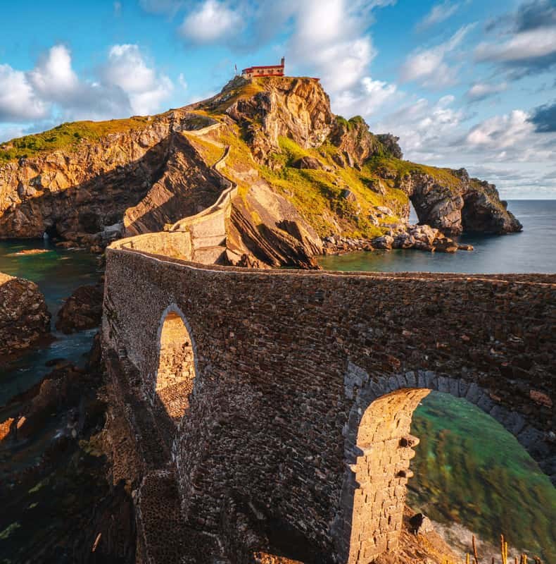
The stone bridge is the halfway point in every sense. It crosses the gap between the mainland and the rock, and the water runs green over the shelf beneath it. The rock strata here are folded almost vertically, which is why so many photographs of this place look faintly unreal.
Stage four: the 241 steps
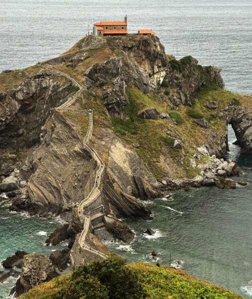
The staircase starts immediately off the bridge and does not let up. All 241 steps are stone, uneven in places, and the flights turn constantly, so the summit disappears and reappears the whole way up. Handrails run along the exposed sections.
| Section | What it is like | Time |
|---|---|---|
| Bridge to first landing | Steepest run, exposed on both sides | 5 minutes |
| The switchbacks | Tight turns, good handrails, best views back | 10 minutes |
| The upper ramp | Gentler, the summit finally in sight | 5 minutes |
| The terrace | Level ground, the hermitage, the bell | As long as you like |
Twenty to thirty minutes with stops is the honest figure. Nobody is timing you, and the landings are wide enough to stand aside and let people pass.
Stage five: the hermitage and the bell
What stands on the summit is a small stone chapel with a bell-gable, a rose window and a studded wooden door, dedicated to St John the Baptist. A ceramic tile on the wall carries his image and the word Laguntza, Basque for help.
Ring the bell three times. The Basque tourism board records the custom plainly: three rings for good fortune, and to send bad spirits on their way. It has outlasted every rebuilding of the chapel, and it is the moment most people describe afterwards rather than the view.
Stage six: the way back
Here is the part the itinerary never mentions. Coming down the steps is quick and easy. Then you cross the bridge and start the 1.1 km climb back to the road, uphill the whole way, usually in more sun than you had on the way down. Reviewers who mention only one difficulty almost always mention this one.
- Keep water for the return rather than finishing it at the top.
- Set off from the summit with time in hand if your group has a coach to catch.
- The steady pace beats the stop-start one on a continuous gradient.
How long the whole thing takes
Ninety minutes to two hours, roadside to roadside, including time at the top. Trips that allow two hours on the headland are giving you the walk without a stopwatch; the access and climb page lists what each one allows, and the visiting guide covers parking and travel times.
What the walk is like in each season
The path and the steps do not change; the conditions around them do. In midsummer the return climb is the whole difficulty, done in full sun with no shade to speak of. In winter the surface is wetter, the wind is stronger and the light on the rock is far better than any August postcard.
| Season | The path | The steps | What to plan for |
|---|---|---|---|
| Spring | Green, occasional mud | Busy at weekends | Book the slot ahead |
| Summer | Dry, dusty, hot on the return | Two-way traffic all day | Take the first slot |
| Autumn | Firm, best colour | Quieter midweek | Shorter daylight |
| Winter | Wet in places | Nearly empty | Wind warnings |
The month-by-month guide goes through the year in more detail, including when the permit windows apply.
Where to stop, and where not to
The staircase is narrow and it carries traffic both ways, so where you pause matters more here than on an open hill path. The landings at the turns are wide enough to stand aside; the straight runs between them are not.
- The gateway: the whole headland in one frame, before you commit.
- The bridge: the classic upward shot, and the natural turning point.
- The first landing: the causeway behind you and the water on both sides.
- The switchback turns: the coast running east towards Bermeo.
- The summit terrace: level ground, the bell, and time to sit.
What not to do is stop mid-flight to check a phone. Somebody is always coming the other way, and the steps are uneven enough that people are watching their feet rather than you.
Walking it in the rain
Rain is not the obstacle people assume. The steps drain well, the stone has grip when it is merely wet rather than greasy, and the crowds thin out considerably. The sea looks better angry than flat, and the light under cloud suits the folded rock.
What changes is footwear and pace. Smooth-soled shoes are genuinely unsafe on wet stone, the handrails become useful rather than decorative, and the path down carries run-off in places. Take the descent slower than you would in the dry and the rest of the walk is unaffected.
If the stairs are not for you
The ridge viewpoints deliver the classic wide view on a level, made path, and they are where most of the photographs you have seen were taken. A coast trip that stops there and carries on to Bermeo, Mundaka and Gernika is a real day out rather than a consolation prize. The things to do page covers what those stops hold, and the questions page answers the accessibility ones directly.